
Both Sides of the Grant Table
October 26, 2026
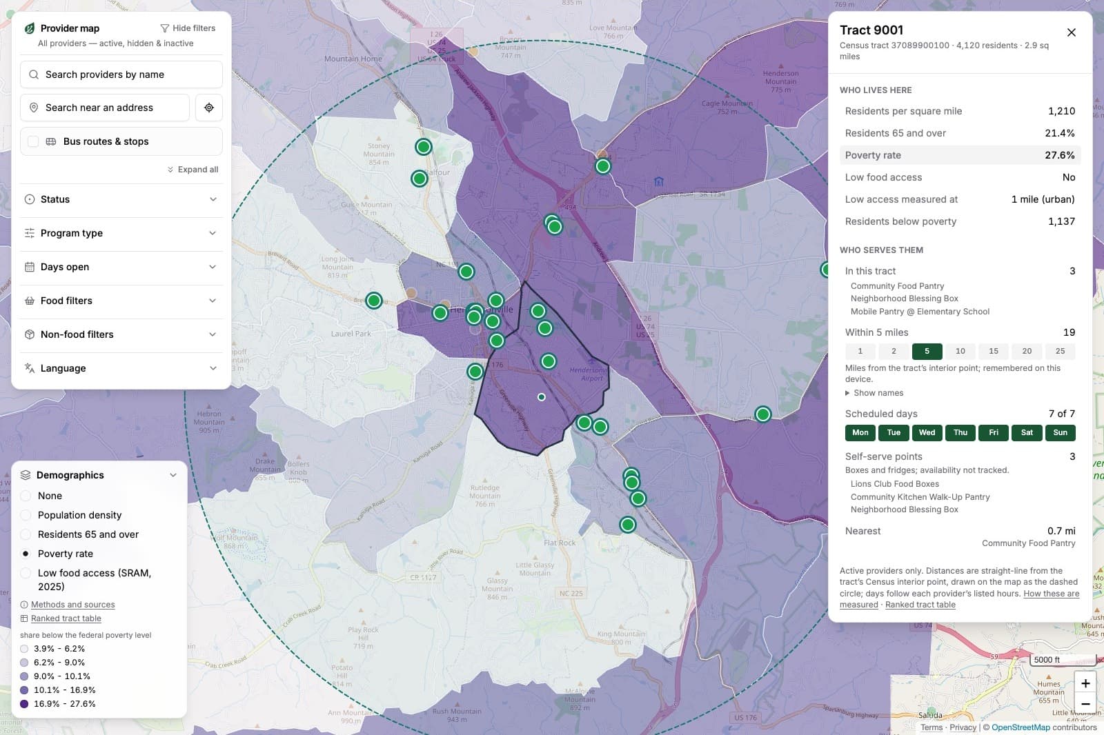
The Henderson County Food Finder went public on September 16. It exists first for anyone in the county looking for food: a verified resource for finding every provider, with hours and requirements that are current. It was also built for a community foundation and the funders working alongside it, so the people deciding where food-security dollars go could see the county's charitable food landscape as it is.
In the weeks since, the people most interested in the data behind the map haven't been funders. In conversation after conversation, charitable food organizations light up at the same idea: using it for grant applications. One sketched the request it wants to write, for a mobile distribution site in a part of the county where people are looking for help and almost nothing operates nearby. Unmet need, demonstrated with evidence a funder can check.
The ecosystem view behind the map was built for funders. The first demand for its data is coming from the people writing to them.
What an application can prove today
Think about what a small food organization has to work with when it sits down to write a funding request. There's the county food insecurity rate, the number at the top of nearly every application in this space, which describes the entire county and is at least a year old the day it's cited. There are its own service counts, which show who came through the door and say nothing about who couldn't get there. There's whatever its last funder required it to track, which is rarely what the organization itself needs to know. And there's what the director sees every week, which is real and specific and reads to a stranger as anecdote.
None of that shows the thing a funder actually wants to know, which is what's missing. A pantry can be the only provider for miles in any direction and have no way to prove it.
Reading from the same map
Now give the applicant and the funder the same verified picture: every provider in the county, confirmed as operating, with days, hours, and requirements as they stand, laid over tract-level need. The application changes. Instead of the county rate and a promise, it can say: here is our corridor, here is everything that operates in it, here is the gap we're proposing to fill. The funder's question changes with it, from "is the need real" to "is this the right response."
In August I wrote that when an application cites the county's food insecurity rate, the next question a funder should ask is a friendly one: what does the current local picture show? The organizations asking for this data are getting ready to answer it.
Funders gain quietly too. Applications built on the same map describe need in comparable terms, something applications built on separate numbers never could. The comparison is between corridors and gaps, never between organizations: nothing a provider shares for the map is a performance measure, and it isn't used as one. And the map keeps showing the gaps no application speaks for, because nobody applies from a corridor where no organization exists.
I'll name the objection, because it's a fair one. A good share of philanthropy is moving toward what the field calls trust-based philanthropy, away from heavy reporting requirements, and for good reason: the data grantees are usually asked to produce is data about themselves, and the reporting load can grow past what any single funder intended, because funders often ask for different versions of it. Small organizations end up tracking what funders require instead of what they need. Ecosystem data is the other kind. Nobody here is asking a pantry to prove itself. The map describes the landscape around the organization, it costs them nothing, and it asks them to track nothing new. A well-run organization would want it even if no funder ever asked, to be sure it's serving where the need actually is. A funder can stay relationship-first precisely because the evidence of need exists independently of anyone's application.
A funder's job was never to police need. It's to make thoughtful decisions about the dollars they steward, and to trust the organizations doing the work to bring their own expertise to what the map shows. That division of labor works when both sides are looking at the same picture, and in Henderson County, for the first time, they can be. Everyone at this table wants fewer hungry neighbors. What's been missing is a shared picture to organize that work around.
What exists today
What exists in Henderson County right now is the verified map and the interest. The usage data that will sharpen these applications builds month by month, and I'd rather show it when it's ready than promise it now. The part that's already settled is the direction of the demand: it came from the organizations closest to the work, before any funder asked for it.
When both sides of the grant table can see the same ecosystem, the same dollars get argued for better and placed better. That picture is what FastRoots builds: every food provider in a county, confirmed through real conversations, by phone and in person when a call can't settle it, re-verified by a person on a recurring schedule, and crossed with tract-level need. If your grantees are making their case from a county rate and a hunch, start here.